Articles
Out See Go
By Chris Engle, contributor
There’s a lot to love about Big Bear Lake near Vienna Corners in eastern Otsego County.
The beach is sandy and wide. Perch fishing from a boat is some of the best around. Just up the road, Big Bear Trading Post routinely has 8 flavors of soft-serve ice cream on tap.
Oh wait, that’s summer.
Right now, the campgrounds (and beach) at Big Bear Lake are closed. There’s not enough ice yet to fish. And the machine that swirls fruit flavors into vanilla ice cream — I lean black cherry — is mothballed for the season. Bah humbug.
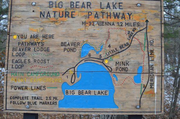
But not all is lost. Winding along the lake and through the neighboring state, forest is Big Bear Lake Nature Pathway, two loops that add up to about 2.5 miles while offering great views of three beaver ponds.
There wasn’t much snow to speak of when I hiked the path Nov. 27 and a pair of light-duty hiking boots with wool socks did me just fine. There are two or three low hills that would call for a bit more effort on snowshoes, but those would be an ideal way to enjoy this trail all winter long. It is not groomed for cross-country skiing.
I parked at the main campground gate and crossed the road to the trail entrance. The loops diverge just a couple hundred feet into the woods, and I took the western loop first.
The west loop is the short-and-sweet version of Bear Lake pathway, offering the best vantage points of two beaver ponds, the bigger of which easily spans 10 acres.
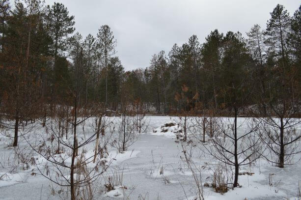
I was able to scoot across the frozen pond to a small beaver lodge, locked in ice and looking pretty quiet this time of year. I’m not very familiar with beaver behavior but I’m guessing they’re still around, though I didn’t see any tracks or air holes where they might come up for a breath.
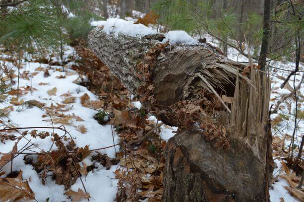
All through the woods there was plenty of beaver sign — large aspen trees chewed through and toppled, their branches stripped off and probably dragged into the pond to be gnawed on. I saw half a dozen trails shooting off the pathway — beaver runs, well worn into the forest floor.
The pathway itself skirts the shoreline so close that it’s flooded over in some spots, offering a beaver’s-eye view of the landscape which has been shaped and reshaped by their activity.
The path loops back across the road and through the campground before connecting to the eastern loop. This is the longer walk and has the most hills, but there is another beaver pond worth seeing if you’re up for the exercise.
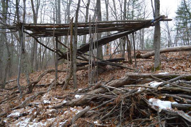
I unexpectedly came across a human habitat of sorts — someone had used beaver-chewed logs to construct a fort with an 8-foot ceiling and supports reinforced with tie-down straps. Someone, probably kids, had put a lot of effort into this fort but a few years have passed since it’s seen any play. Just then, two A-10 Thunderbolt warplanes from the nearby National Guard range passed overhead, convincing me kids have had fun playing war games here in the middle of the woods.
One stretch of the eastern loop shares a snowmobile trail under a set of power lines, so be aware should you go snowshoeing there. Some of the trail markers were lost during recent brushing under the lines, so watch closely for blue blazes where the trail exits and reenters the woods.
The whole hike took a little over an hour with frequent photo stops and one coffee break at my car between loops. By the end of it all I was pretty hungry, and even though the ice cream’s not flowing, the Trading Post up the road always has hot pizza.
Chris Engle lives in Hayes Township, Otsego County. He can be reached at englemobile@gmail.com.