Articles
The morning sun is bright on the windshield as we speed along the gentle curves of Sturgeon Valley Road toward the Shingle Mill Pathway in the Pigeon River Country Forest. Although it is late May – Memorial Day weekend in fact – the trees on either side glow a brilliant spring green. I look forward between my brother-in-law and sister-in-law in the front seats. They are visiting from the Kalamazoo area for the weekend. As avid cyclists (both road and mountain), they never miss an opportunity to explore a new trail.
I keep my eye out for the bridge that crosses the Pigeon River. When I spot it, I tell Will to park in the dirt parking area to the south of the road, on the right just after crossing the bridge. We get the bikes unloaded, clip on helmets, and secure our hydration packs to our backs. I lead Will and Renee across the paved road into the small campground nestled in the corner made by the road and the river.
At the trailhead I let Will take the lead. At over six feet tall and a carpenter by trade, he’s the strongest rider in our little group. Renee and I are both about the same size, around 5 feet 4 inches. But one would be mistaken to judge us on our small stature. Renee is a ‘roadie’ as she calls it and tough as nails. Every Saturday morning she joins a group of guys and one other woman for a blisteringly fast road ride. Although she doesn’t mountain bike as often as Will, she can hold her own on the single-track trails as well.
The large white pines close in and immediately we’re in a different world. The sunlight filters through the canopy and dapples the pine needles that layer the ground. The packed single track rolls away under my tire as I concentrate on avoiding the occasional tree root and keeping up with Will in front of me. The trail narrows as we get farther from the campground. When we pass the sign for the 2 mile loop, I can tell that less people venture farther than this point.
Before we get too far, we pass a lone biker going the other direction. Then it’s just us, the sun, the trail, and the woods for miles. It’s hard to believe we are only 25 minutes from downtown Gaylord and even closer to little Vanderbilt. Here on this rustic trail I feel like we’re the only people out here, three small dots in the expanse of 100,000 acres of Pigeon River Country Forest.
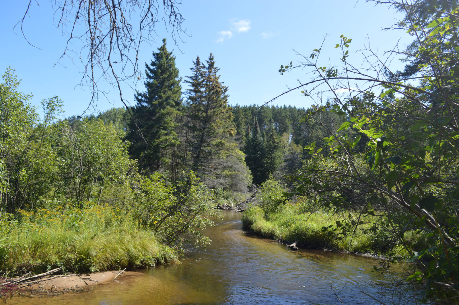
The trail dives down to meet the Pigeon River and I steal some glimpses of it on my left as I keep an eye on what’s in front of me. The water flows in the direction we’re going and I feel for a second like we’re racing the ripples on their way to the north. Then the river is gone as the trail leaves it to take a more direct route towards the Pigeon River Headquarters. I follow Will for about a mile with Renee behind me before we come out onto the gravel drive in front of the Headquarters.
We slow our pace and look around. The big log building on our left is familiar enough as I’ve visited on numerous occasions. If we were to stop, we’d find more information, maps, and displays inside. But there’s something new here too. A crushed gravel path leads from the right side of the building back to a smaller log building behind it. Built in the 1930’s, it used to house the Civilian Conservation Corps (CCC) unit managers. Now it is in the process of becoming the Pigeon River Country Discovery Center, an historical interpretive center.
I smile at the progress that’s been made on the project. My partner, Alex, and I have been exploring the Pigeon River Country since we moved to the area seven years ago. Although we have our favorite spots, we are always finding new areas to explore. When the opportunity arose for our small business to help sponsor some of the construction here, we jumped at it.
I don’t have too long to admire the new construction. We continue our ride onto the new crushed gravel path and then almost immediately take a right to follow the single track as it disappears into the woods again. In less than a mile we slow our pace when the trail spits us out into another campground. We navigate the gravel roads running through the campground by following the blue blazes on the trees. The road ends up running parallel to the Pigeon River and I can see it through a screen of trees. Then we take a left and the river comes into full view as we approach a bridge that will take us over it. A small boy stands next to the rail, looking over the edge. We wave at him as we pass.
Once over, the road turns to the right and we ride along the river, this time on the west bank. I keep an eye out because I know the single track starts up again on our right, between the road and river. It’s easy to miss, but we spot it and Will leads us through this overgrown section. The earth is moist – muddy in some places – and the grass is tall and damp. At some points, bushes reach into the trail and I duck my head to avoid getting hit in the face. All the plants down here are lush and wet so close to the river, in stark contrast to the dry pine woods we’ve come from.
As we come up out of the river bottom, we hit the intersection for the 6 mile loop. We take the trail on the right, heading north towards the 10 and 11 mile loops. This section is high and dry as the trail leaves the river. For a little under two miles we ride through hardwoods. The gently rolling uplands take us down into little valleys and back up again.
We stop at the intersection for the 10 and 11 miles loops. I’ve never been on the 11 mile loop section, but I know the 10 mile section is beautiful. It passes a sinkhole lake – a perfect circle of deep turquoise water down below the trail – and crosses a creek that flows into Grass Lake. Riders can catch glimpses of Grass Lake on the way up to the overlook. But all three of us want to go farther, and I’m curious to see what the 11 mile loop section is like, so we take the right trail.
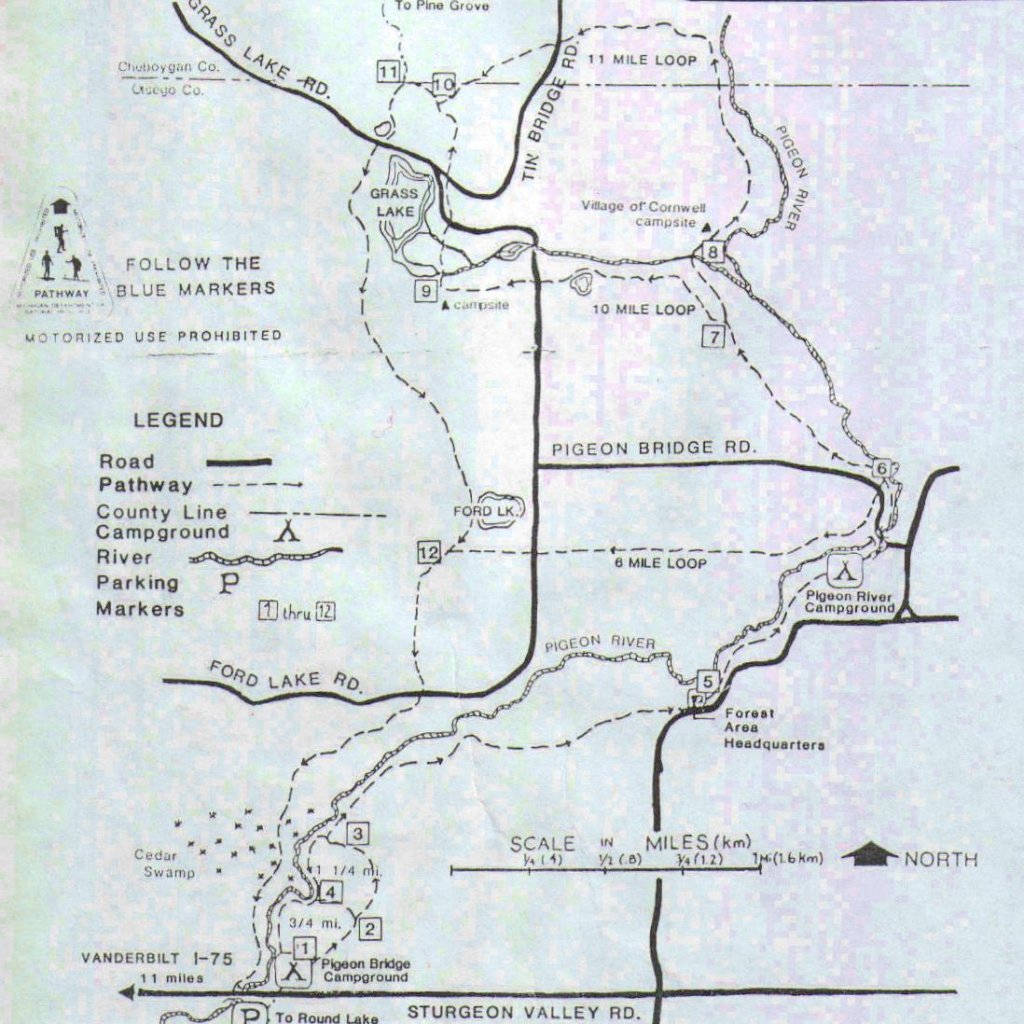
Shingle Mill Pathway map from: http://www.otsego.org/prca/smpw/smpw.htm
Almost immediately we cross a little creek and struggle up a steep and root-filled incline. I can tell right away that this section of the trail isn’t traveled as often as the 10 mile loop section. The single track narrows to not much wider than my tires. We pass through some hardwood groves and then are reunited with the Pigeon River once again as we dip down into an open, grassy area on the river bank. We struggle through a wet section of trail before climbing through hardwoods once again, our legs covered in mud. Almost immediately we see a couple backpackers up ahead. They have long pants and sleeves on and sport head nets to keep the mosquitoes away.
Apologizing for our loud intrusion, we pass them and continue through some tough climbs. I’m breathing heavily as we crest the last one. Renee and I have fallen a bit behind. Will waits for us after we cross a two track and end up on what looks like an old logging road. We take a quick break. Before we hit the trail again, the two backpackers come up behind us. I point them in the direction of the easily-missed single track heading off to the right of the logging road, knowing we’ll be passing them once again shortly. We hop on our bikes and leave the old logging road for the single track.
As we leave the backpackers behind once again, I imagine hiking this trail and for an instant regret our fast pace. It’s what I love and hate about mountain biking – the speed. It creates the challenge that makes mountain biking so addicting, but it also means I’m missing all those things I would have noticed if I’d been on my own two feet.
My musing is interrupted by an exclamation from Will ahead of me. I look up and instantly see a big black shape moving quickly through the trees away from us. The angle that the creature has taken makes its profile clear to me. It is definitely a black bear, and it is definitely the closest I’ve ever seen one in the wild. It must have been only 35 feet up the trail from us when it bolted. I know that black bears are much smaller and less aggressive than other types of bears, but the size of this one startles me. My nervousness is only heightened when Will asks if I can see the bear cubs.
By now the three of us are all stopped in the middle of the trail as we gaze up at the two cubs looking down on us. They have each found their own birch tree to climb. Will says they were 40 feet up within four seconds of seeing him. Both are completely black except for their light brown snouts. Their little rounded ears are perked up as they try to gather as much information as possible from their surroundings. The birch trees are tall and in this thick canopy they don’t have any branches until much farther above the cubs. The one I’m watching looks down at us, then over its shoulder. It is clearly nervous as it climbs a bit higher. They are so small, like a couple of beagles up in the trees.
However, I’m very conscious of the fact that they are not beagles. All of the stories I’ve heard of aggressive black bears have involved cubs, and I don’t want to linger too long. Will and Renee feel the same and before we can even think to take pictures, we are on our bikes again, leaving the little cubs behind high in the trees.
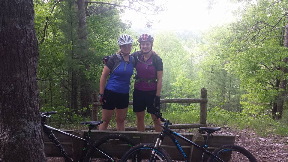
The excitement of seeing the bears wears off as we travel farther along the trail. After a little climb we come to an intersection and follow the sign to an overlook. A bench sits in front of the view. The full foliage of spring is spread out in front of us. I can only imagine what it looks like in full fall colors. We snap a couple pictures and head back to the intersection. We’ve delayed long enough that the backpackers have caught up with us again. We chat for a bit and learn that they are from Grand Rapids and they’ll be camping off the trail tonight.
At the overlook
We take our leave of the two backpackers for the last time. Skirting around a little lake, we ride past Grass Lake. We don’t get to see as much of it as we could have from the 10 mile loop which follows the east side of the lake as well. After a couple miles of hardwoods and then an open area of young pine, we hit Ford Lake, pass another backpacking couple, and then pass the intersection for the 6 mile loop. We are getting closer to the end of the trail, but I know we still have some challenging sections coming up.
As we draw closer to the Pigeon River again, we come to a cedar swamp. We enter this dark, cool part of the forest and the path rides up onto a two-plank pathway about two feet wide. The planks sit atop logs, putting us about a foot and a half above the forest floor. It is a little disconcerting to think of the extra height we would fall if one of our tires slips off the planks.
As we continue farther into the swamp, the plank pathway just keeps going. Later I’ll read that it is about a quarter of a mile long, but right now it just seems to go on forever. It twists and turns between cedar trunks. I notice the deep moss covering the forest floor, but I can’t look around too much for fear I’ll slip off the planks. I can hear Renee’s exclamation as we come to the end of the plank pathway. There are so many roots that there is no avoiding them. I try to gain speed, but the roots rise up in a lumpy mass that almost stops me. I bump from one root to the next. They finally come to an end after I pedal through a grassy clearing.
Will and Renee are waiting for me. Almost right away we are biking up the short incline to Sturgeon Valley Road. Once we reach the level black-top we take a left, crossing the Pigeon River one last time before arriving at the dirt parking lot. We are tired, sweaty, and muddy, but we are all beaming. We’ve had a blast on the varied terrain of the Shingle Mill Pathway. We throw our gear in the trunk and load the bikes on the rack. As we drive west along Sturgeon Valley Road, I imagine three bears wandering deeper into Pigeon River Country. They may forget their chance encounter with three bikes on the Shingle Mill Pathway, but I definitely will not.
Jessica Kane is a small business owner and outdoor enthusiast living near Gaylord, Michigan. She can be reached at jkane@line-45.com. For more information about the Pigeon River Country, visit the Pigeon River Country Association.